


| ü@ | ü@ | ü@ |
| ü@ | In the early Edo era,Lord Okabe had cedar trees(sugi)planted along the Ome Road,thus indicating the boundary of his fiefdom. These roadside cedar trees(suginami)were gone before the Meiji era,but the village name of Suginami remained.Suginami grew to become a town,and eventually became the official name of modern city of SUGINAMI | ü@ |
| ü@ | ü@ | ü@ |
| ü@ | ü@ | ü@ |
| ü@ | Suginami City is on the MusashinoPlateau and is situated at the western end of Tokyo's 23 cities,being generally referred to as "josai chiku"or "west of the castle area"because of its location.On its eastern border are Nakano and Shibuya cities and Mitaka City and Musashino City are to the west. On its southern boundary is Setagaya,and Nerima City is to the north. Suginami City is the eighthlargest city,with 34.02 square Kilometers. | ü@ |
| ü@ | ü@ | ü@ |
| ü@ | ü@ | ü@ |
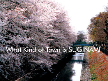
| ü@ | The three major rivers in the city are the Myoshojigawa,Zempukujigawa and Kandagawa rivers,which once provided the residents with water for both irrigation and drinking.Today these flood-controlled rivers have new roles,creation relaxing waterfront areas for residents. | ü@ |
| ü@ | ü@ | ü@ |
| ü@ | ü@ | ü@ |
| ü@ | The lush green areas of Zempukuji Pond,IgusaHachimangu Shrine,and the riverbank area of the Zenpukujigawa River,which runs along OmiyaHachimangu Shrine,are designated nature preservation areas. By law these areas are excluded from housing development.These green belts create relaxing strolls for city residents. Zempukuji Pond is said to be one of the three most beautiful ponds in Musashino(the ancient name of Tokyo),along with Inokashira Pond in Mitaka City and Sanpoji Pond in Nerima. The remains of ancient houses are presered in the vicinity of IgusaHachimangu and Omiya Hachimangu shrines. | ü@ |
| ü@ | ü@ | ü@ |